Changing the perception, one bay at a time…
Greetings! Offered here is a new approach to socializing the Google Earth-based Carolina bay survey, which in its current version has been renamed to OvoidBasinSurvey to recognize other ovoid depressions in North America that conform robustly to specific archetype planners, but here using a "slider" visualization tool within a generic web browser window - no Google Earth required! With it, a bay can be seen in digital elevation maps created with LiDAR, and using the slider, the planform which has been fitted to the bay can be rolled on and off. As the user controls the slider, the fit of the planform shape can be tracked against the actual rim, as the measurement overlay often obscures the finely-scribed rim berm structure beneath it. We encourage the user to see for themselves how robustly the true shape of the bays can be matched to the archetype template. It is vitally important that the viewer recognize that the presented "template overlay" is a raster image and can only be adjusted for rotation (clockwise from North) and length/width (eccentricity). Presented images relate my personal subjective fit of the template, and users are invited to use Google Earth Pro with the KMZ file that is linked on each basin's page here to perform their own subjective "fit" by adjusting the position of the template using Google Earth's edit functions.
As of August, 2025, the imagery in the site has been re-rendered to display "4K" graphics, as provided by the latest USGS LiDAR data, much of it being rendered at 50 cm resolution. The effect compared to the older, lower resolution data and display resolution is stunning. The effect is best experienced by pushing your browser into "Full Screen" mode by clicking on the image. Hopefully you have a 24' or larger monitor to view all the detail.
Basis are presented "normalized" for bay-to-bay comparisons. The featured basin is rotated so that its major axis runs left to right, and it is scaled such that the basin occupies 2/3 of the image's width. Each image includes a color-to-elevation index that references the 10-meter cyclic color pallet that has been developed for my survey efforts. The color applied to the image is related to the USGS elevation of the basin MODULO 10. There is also artificial hill shading done to aid in the visual illusion of 3D - in these images it is "shining" from the left side of the screen.
The images presented are under 4 Mbytes, so network connectivity is not a big issue here. That's the point, as Google Earth alone does not reach enough of the possible audience for this conversation. And the conversation is hopefully simple: these landforms conform to an archetype shape way too robustly to be the work of gradualistic "wind and wave." I hope the visualizations will inspire the viewer to at least consider that they may have a catastrophic genesis. No, not impact craters (they are far too shallow), but perhaps some other collateral damage from an impact event during the Pleistocene. And no, not the YDB, as they are far too ancient to be younger than hundreds of thousands of years old.
Our first 500 bays are drawn for a pool of 15,000 bays found within two USGS 1º quadrants: Florence_W and Florence_E. They can be seen by following the menu: bayCarolina > 500 bays. Among these bays are a number of the largest, comprised of a complicated assemblies of planforms. The set also adds about 50 smaller bays that are cohorts of larger bays, meaning they are conjoined or integrated in making up the present shape of a basin. A selected subset of 250 single bays is also available at the bayCarolina > 250 Singles menu item.
Bays can be traversed Largest to Smallest using the arrows at the bottom of the page, or by selecting any of the indexes shown on the page. For instance, you might have a look at all the bays that have an eccentricity of 0.76 using this LINK. Or perhaps view all the bays that are tagged as presenting a "bow" formation (SE end of basin sets significantly higher than terrain further SE) HERE. Similarly, all bays in the major axis category having a value between 1600 and 1700 meters can be accessed via the1600 link.
Google Earth users can also dive into a spatial index of the selected bays the two quadrants with this KMZ. From there, the place mark popups offer a link to the presentation page for the selected basin using this browser-based viewer. If you desire Google Earth to be populated with the HRTM overlays, please preload the LiDAR-HRTM kmz file for the Florence W&E quadrilles.
Future work will include expanding the bayCarolina "slider" pages to a total of 1500 (10%) randomly selected, basins, hopefully creating a statistically relevant presentation of their family relationship. Adding similar sets of bays for the other archetype planforms identified in the Survey is a long range goal.
Their very randomness of grouping and scatter demands an explanation. As a statistical phenomenon, they deserve to be studied statistically.
W.C. Rasmussen, 1953
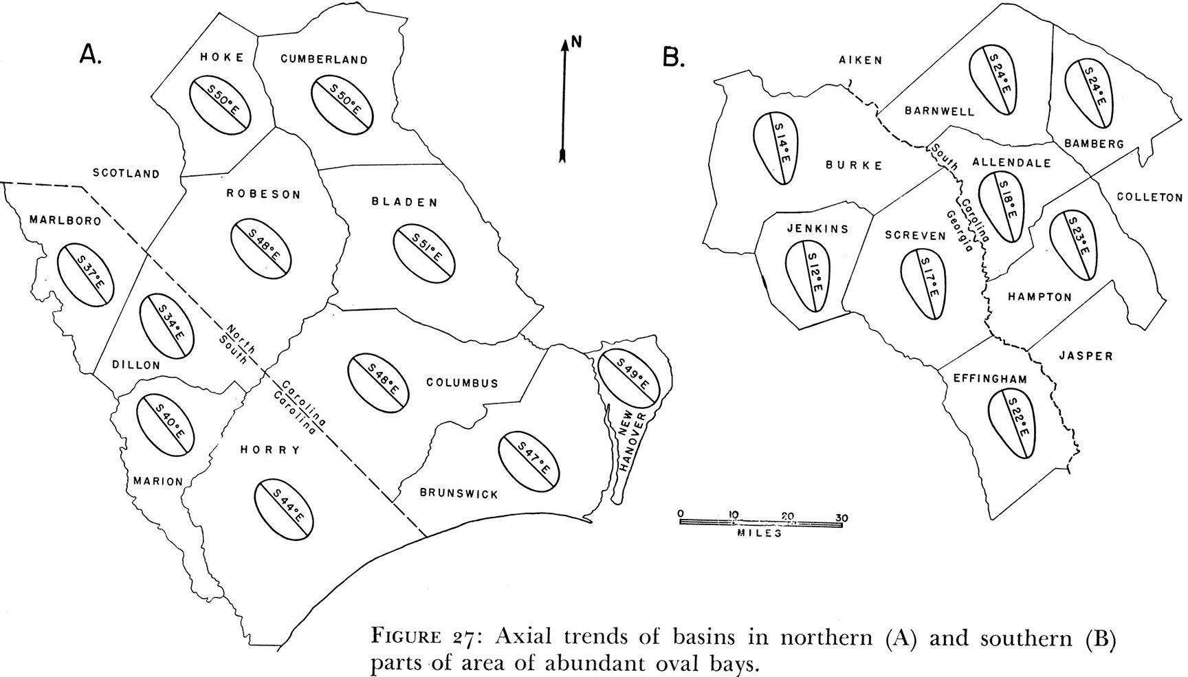
Dr. Douglas Johnson documented two species of Carolina bay planforms with figure 27 from his book The Origin of the Carolina bays: the oval and the teardrop.
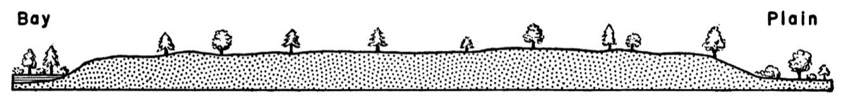
Johnson also characterized the rims of bays as being a broad, flat pediment that surrounds these gentle depressions. We call this out, as may geologists consider only the superficial wind-driven dunes which decorate a small percentage of southeastern bay rims as being the "rim" of the bay. many researchers are totally enamored in those dunes, and spend all their time investigating when those dunes were emplaced. As if that had anything to do with the creation of the bays!
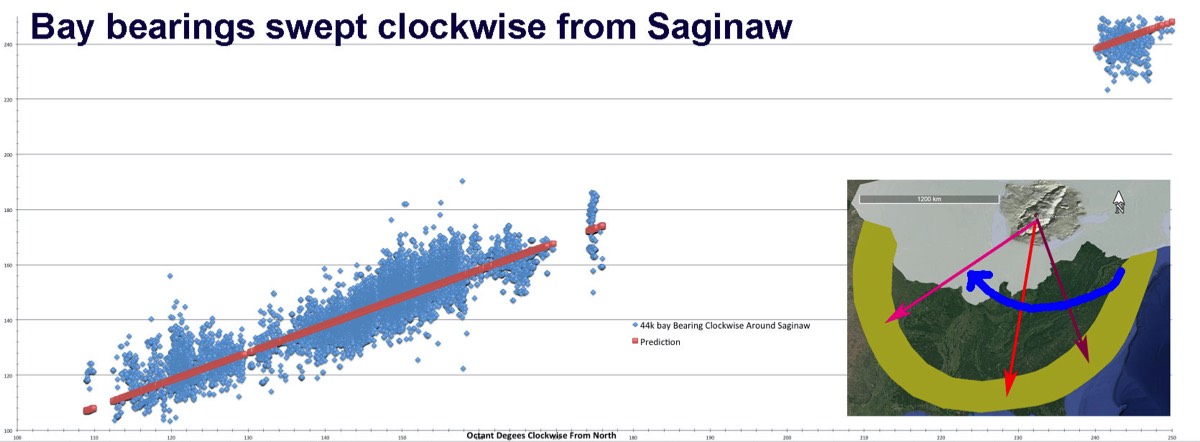
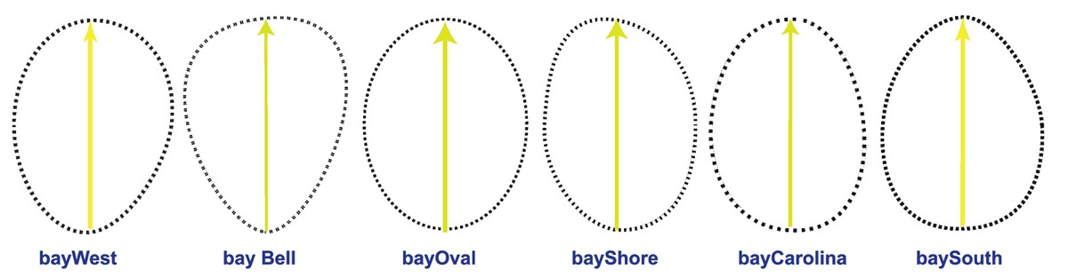
The Carolina Bay Survey has identified six planforms which satisfactorily match the geospatial 2-D shape of Carolina bays. The six shapes are generally specific to geographic regions, although some overlap exists where one shape transitions into another. One shape found rarely is a pure oval, while the other five are slight variation on the basic oval shape. These have been named bayWest, bayBell, bayShore, bayOval, bayCarolina, & baySouth, respectively as they are found on clockwise rotation from Nebraska to Louisiana.
Our observation that these planforms map robustly to the bay types, and the indicated orientations rotate systematically by their spatial relationship to the Lower Peninsula of Michigan, suggests to us they are related to a cosmic event at that focus.